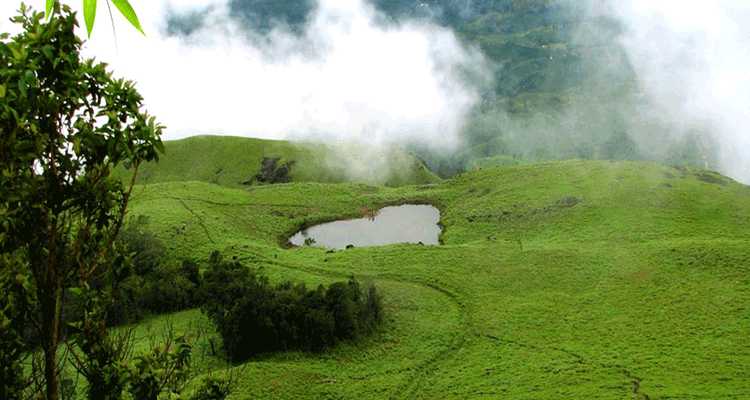
Chembra Peak
The highest peak in Wayanad, offering breathtaking views and a heart-shaped lake.
Chembra Peak is the highest mountain in Wayanad district, Kerala, standing at 2,100 meters (6,890 feet) above sea level in the Western Ghats near Meppadi town. Located approximately 18 kilometers from Kalpetta, the peak is famous for its heart-shaped lake situated midway along the 3.5-kilometer one-way trek. The complete round-trip trek typically takes 4-5 hours and is classified as moderate to hard difficulty. As of 2024, Chembra Peak is currently closed to visitors due to recent landslide damage affecting the Wayanad region, and visitors should check local authorities for reopening updates before planning any visit.
Current Status
Chembra Peak remains closed to visitors following the devastating landslides that impacted Wayanad in 2024. The closure is a precautionary measure implemented by the Forest Department to ensure visitor safety and manage the geological and environmental aftermath of these natural disasters. The trekking routes, forest trails, and surrounding infrastructure have been significantly affected by landslide activity, erosion, and subsequent debris flow. While the peak has been an iconic attraction for decades, the severity of recent geological events necessitated this indefinite closure. Visitors planning trips to Wayanad should consult official Forest Department channels, local tourism websites, and current travel advisories to determine when the site may safely reopen. Alternative attractions within Wayanad remain accessible, including Edakkal Caves, Soochipara Waterfalls, and the Lakkidi Viewpoint.
Location and Geography
Chembra Peak is situated in the Western Ghats mountain range, which forms the spine of the Wayanad district in northern Kerala. The peak’s geographic coordinates are approximately 11.5333°N latitude and 76.0833°E longitude. With its elevation of 2,100 meters (6,890 feet), it represents the highest point in Wayanad district and commands panoramic views of the surrounding tea plantations, forest areas, and distant landscapes. The peak lies within or near several protected forest areas and is surrounded by dense shola grassland and montane vegetation typical of the Western Ghats.
The nearest population center is Meppadi, located approximately 8 kilometers from the peak’s base. Kalpetta, the district headquarters of Wayanad, is situated 18 kilometers away and serves as the primary gateway for most visitors. Vythiri is another nearby town, roughly 26 kilometers distant. The broader region is connected to major cities through established road networks, with Kozhikode (Calicut) being the nearest metropolitan area at approximately 79 kilometers away. The terrain surrounding Chembra Peak is characterized by rolling hills, tea estates, cardamom plantations, and tropical forests interspersed with human settlements and agricultural lands.
How to Reach Chembra Peak
By Air
The nearest airport is Calicut International Airport (Kozhikode International Airport), located approximately 92 kilometers from Chembra Peak. This airport connects to major Indian cities including Mumbai, Delhi, Bangalore, and Chennai, as well as international destinations. From the airport, visitors can hire taxis, book ride-sharing services, or use bus facilities to reach Kalpetta, which then requires further travel to Meppadi and the peak’s base.
An alternative airport is Kannur International Airport, situated roughly 95 kilometers away, offering additional flight connectivity options. Bangalore International Airport, about 289 kilometers away, serves travelers from southern India with a wider range of domestic and international flight options.
By Train
Kozhikode Railway Station (also known as Calicut Railway Station) is the primary rail gateway, located 79 kilometers from Chembra Peak. This station is well-connected by rail to major Indian cities including Trivandrum, Cochin, Bangalore, and New Delhi. From the railway station, visitors must travel by road (approximately 1.5-2 hours by taxi) to reach Kalpetta and subsequently Meppadi.
Alternative railway stations include Kannur Railway Station (approximately 95 kilometers away) and Wayanad Railway Station in Lakkidi, offering additional rail connectivity options for travelers arriving from different directions.
By Road
From Bangalore (approximately 289 kilometers), travelers typically follow NH766 southward through Karnataka and into Kerala, eventually reaching Kalpetta via established highway routes. The journey from Bangalore typically takes 5-6 hours by car.
From Kochi (approximately 276 kilometers), the route leads northeast via NH44 and connecting roads through the hilly terrain of central Kerala, requiring approximately 6-7 hours of travel time by vehicle.
From Kalpetta to Chembra Peak is 18 kilometers, requiring travel via the Kalpetta-Meppadi Road. The route follows a moderately winding road through tea plantations and forest areas, taking approximately 45 minutes to 1 hour by car or taxi.
From Meppadi town, visitors must travel an additional 7 kilometers to reach the base of Chembra Peak. This final stretch is a rough mountain track suitable mainly for vehicles with good ground clearance such as jeeps or high-clearance SUVs. The road passes through forest areas and may be challenging during monsoon or immediately after heavy rains.
Regular bus services operated by KSRTC (Kerala State Road Transport Corporation) and private operators connect Kalpetta with most major towns in Kerala, making bus travel an economical option for reaching the district.
The Heart-Shaped Lake
The heart-shaped lake is the most distinctive feature of Chembra Peak, located approximately midway along the trekking route at an elevation around 1,600 meters. This natural freshwater lake is formed on the plateau and has become iconic within Wayanad’s tourism landscape, frequently featured in photography collections and travel guides. The lake’s shape resembles a heart when viewed from above, though ground-level perspective reveals it as a more irregular water body surrounded by shola grassland.
According to local mythology and traditions maintained by the tribal communities of Wayanad, the lake never completely dries up even during the hottest summer months, though water levels do fluctuate seasonally. This permanence has made it a source of fascination and spiritual significance to local populations. The lake is believed to remain cool throughout the year and is considered sacred by various indigenous groups in the region.
The heart-shaped lake serves as an ideal rest point during the trek, allowing trekkers to catch their breath, consume water and snacks, and enjoy photographic opportunities before continuing the more strenuous final climb to the peak. The area surrounding the lake provides some of the most picturesque views on the entire trekking route and has become a mandatory stop for most trekking parties.
Chembra Peak Trek: Route and Details
The trek to Chembra Peak begins from the designated starting point located 7 kilometers beyond Meppadi town. The trail initially descends through established tea plantations that characterize the lower elevations of Wayanad. These plantations are actively managed and regularly harvested, creating a cultivated landscape quite distinct from the natural forest areas encountered at higher elevations.
The trek route spans 3.5 kilometers one way, with the return journey covering the same distance. The overall round-trip distance of 7 kilometers is typically completed in 4-5 hours, including rest breaks. The trek is classified as moderate to hard difficulty, requiring reasonable fitness levels and proper footwear. The trail gains approximately 500 meters in elevation, creating a steady but unrelenting uphill climb with varying gradient sections.
The first phase of the trek, covering approximately 1.5 kilometers, leads through active tea plantations with a moderate upward gradient. During this section, trekkers gain approximately 200 meters in elevation and encounter occasional plantation workers. The trail is relatively clear and well-marked by local guides and frequent visitors.
The second phase, approximately 1 kilometer in length, transitions from cultivated plantation areas into natural forest zones. This section becomes noticeably steeper and more challenging, with the trail becoming narrower and more technical. The gradient increase and vegetation changes mark a distinct transition in the trekking experience.
The third phase leads to the heart-shaped lake, where most trekking parties take a substantial rest break. This section covers roughly 1 kilometer and involves moderately steep climbing through grassland and open forest areas. The lake sits at approximately 1,600 meters elevation and provides a natural midpoint for the journey.
The final phase from the lake to the summit covers approximately 0.5 kilometers but is significantly steeper than preceding sections. This section involves rock scrambling in places and requires careful foot placement. The final approach to the peak emerges from vegetation onto open grassland and rocky terrain.
Trek Permits and Bookings
Trekking to Chembra Peak (when open) requires an official permit issued by the Meppadi Forest Office, which is part of the Kerala Forest Department administration. The Forest Office is located in Meppadi town, approximately 8 kilometers from Kalpetta.
The standard permit fee is rupees 750 per group, with a maximum of 10 people permitted per group. This fee provides access to the trekking trail and supports forest management and conservation activities in the region. Individual permits are not issued; groups must trek together under a single permit.
Visitors must provide valid identification documents (such as passport, Aadhaar card, driver’s license, or voter ID) at the time of permit application. The trekking window is from 7:00 AM to 2:00 PM, meaning groups must secure their permits during these hours from the Forest Office, with the actual trek typically conducted between 9:00 AM and 2:00 PM to allow sufficient daylight for safe descent.
It is advisable to obtain permits on the same day as trekking or on the preceding day by visiting the Forest Office in person. During peak seasons (September through February), early morning permit acquisition is recommended to avoid delays or full capacity situations.
History and Tribal Significance
The Chembra Peak region has held cultural and spiritual significance for the indigenous communities of Wayanad for centuries. The Kurichiya and Paniya tribes, among other indigenous groups inhabiting the Wayanad district, have maintained historical and spiritual connections to the peak and the broader landscape.
For these tribal communities, the peak served not merely as a geographical landmark but as a place of worship, ritual significance, and practical importance as a vantage point for understanding the landscape. Various myths and legends, passed down through oral traditions, associate the peak with divine or supernatural elements. The heart-shaped lake, in particular, features prominently in local folklore and is believed to possess spiritual properties.
During the colonial era under British administration, the Wayanad region underwent extensive transformation as part of plantation development policies. The peak’s surrounding areas were gradually converted to tea estates, spice plantations, and coffee estates, dramatically altering the landscape while the peak itself remained largely undeveloped. The tribal communities experienced significant displacement and changes to their traditional livelihoods during this period.
In more recent decades, the peak has been recognized as a tourism asset and trekking destination, attracting visitors from across India and internationally. This transition has created both opportunities and challenges for local communities, introducing economic benefits through tourism while potentially diluting cultural traditions and straining local ecosystems.
Flora and Fauna
The Chembra Peak region encompasses diverse ecosystems typical of the Western Ghats, ranging from managed agricultural areas at lower elevations to natural montane forest and shola grassland at higher elevations.
The lower elevations (up to 1,200 meters) are dominated by tea plantations, spice gardens, and mixed agricultural lands maintained by human populations. These cultivated landscapes support limited wildlife but provide habitat for various bird species and small mammals adapted to human-influenced environments.
The mid elevations transition into natural forest composed of mixed deciduous and semi-evergreen species typical of the Western Ghats. These forests support diverse vegetation including large trees, epiphytic plants, and dense understorey vegetation. The forest canopy provides habitat for numerous bird species, primates, and small mammals.
The higher elevations feature shola grassland, a distinctive ecosystem characteristic of the highest peaks in the Western Ghats. This grassland comprises natural meadows interspersed with low shrubby vegetation and patches of stunted forest. The shola grassland is particularly biodiverse and supports numerous endemic plant and animal species found nowhere else in the world.
Large mammals present in the region include Asian bison (gaur), which occasionally descend from higher forest areas into the peak region, and Asian elephants, which roam the broader Wayanad landscape. Smaller mammals include various species of langurs and primates, civets, porcupines, and other forest dwellers. These animals are typically encountered only by observant trekkers and are often more common in early morning or dusk hours.
Avifauna is exceptionally diverse, with species including the Nilgiri pipit, various eagles and raptors, laughing thrushes, and numerous migratory species during certain seasons. The open grassland areas provide habitat for ground-nesting birds and open-country species.
Reptile fauna includes various snake species, lizards, and amphibians, many of which are endemic to the Western Ghats. Leech populations are particularly abundant during monsoon months when humidity levels are high, making leech-related precautions necessary during monsoon-season treks.
Best Time to Visit
The optimal trekking season spans September through February, when weather conditions are most favorable for outdoor activities. During this period, daytime temperatures range from 15-25 degrees Celsius at the peak, with clear visibility providing excellent panoramic views.
September and October mark the post-monsoon period when rainfall has diminished, vegetation is lush green, and water sources remain abundant. The landscape appears rejuvenated, and visibility typically improves as atmospheric moisture decreases.
November through February represents the peak dry season, characterized by clear skies, moderate temperatures, and minimal rainfall. This period attracts the highest number of visitors and offers the best photography conditions.
The monsoon season (June through August) brings heavy rainfall, making trails slippery and hazardous. Leeches become extremely active during this period, visibility decreases due to clouds and mist, and the accumulated moisture creates treacherous conditions. Trekking during monsoon is generally not recommended.
March and April constitute the summer months, with higher temperatures and lower humidity. The landscape appears drier, with vegetation less vibrant than the post-monsoon period. However, trekking remains feasible during these months for visitors with appropriate fitness levels and sun protection.
May is the pre-monsoon period, characterized by increasing heat and declining air quality in some areas as dust becomes suspended. Trekking is possible but less comfortable than other seasons.
What to Pack
Proper preparation and packing are essential for a safe and comfortable trek to Chembra Peak.
Footwear should consist of sturdy trekking shoes or hiking boots with good ankle support and grip. Open sandals or light shoes are unsuitable for the uneven terrain and rocky sections encountered on the trail.
Water containers should include at least 2-3 liters of water per person, as water sources along the trail are limited. A refillable water bottle reduces the weight of carrying the entire quantity from the start.
High-calorie snacks and light meals are necessary for sustenance during the trek. Recommended items include trail mix, energy bars, fruits, biscuits, and sandwiches. These items provide energy without adding excessive weight.
Weather-appropriate clothing should include light layers, as temperature decreases significantly with elevation gain. A lightweight waterproof jacket or raincoat is essential, as sudden rain can occur even during the dry season.
Sun protection items including sunscreen lotion, sunglasses, and a wide-brimmed hat are important, particularly during the dry season when sun exposure is intense.
A valid identification document (passport, Aadhaar, driver’s license) is legally required for permit acquisition.
A small basic first-aid kit including adhesive bandages, pain relievers, and blister treatment can address minor injuries.
A mobile phone with fully charged battery can provide emergency communication, though cellular coverage is intermittent along the trail.
A camera or smartphone for photography is recommended, particularly for the heart-shaped lake and summit views.
Photography Tips
The heart-shaped lake represents the most photographed location on the trek, particularly during clear morning hours when light angles are favorable. The surrounding grassland and water reflections create excellent photographic conditions.
Summit views are most dramatic during sunrise, when low-angle sunlight creates long shadows and highlights landscape features. Sunrise photography requires an early departure from the trekking base to reach the summit during the golden hour.
The tea plantations visible from various points along the trail create picturesque foreground elements for panoramic landscape photography, particularly with the distant valleys and mountains in the background.
Misty mornings, commonly occurring in the post-monsoon and winter seasons, create atmospheric conditions ideal for moody landscape and forest photography, though such conditions reduce long-distance visibility.
Portrait photography of trekking companions against the landscape backdrop can capture personal experiences, best conducted at the heart-shaped lake where rest stops provide time for such activities.
Macro photography opportunities exist during seasons with active flora and fauna, particularly insects and small plants in the shola grassland areas.
Safety Guidelines
Leeches constitute the primary biological hazard during monsoon months, becoming active and numerous in moist conditions. Hirudoid cream, salt, or repellent products can reduce leech attachment. Immediate removal and wound disinfection prevent infection, with anti-itch creams providing relief from itching.
Slippery rocks and wet surfaces pose injury risks, particularly after rain or during early morning hours when dew creates slick conditions. Careful foot placement and appropriate footwear are essential for preventing falls.
Weather conditions can change rapidly in mountainous terrain. Cloud cover can reduce visibility suddenly, and unexpected rain can occur even during the dry season. Trekkers should be prepared to retreat if weather becomes dangerous.
Solo trekking is not recommended due to isolation risks and limited assistance availability if injury occurs. The minimum group size should be 2-3 people, though guided treks with Forest Department approved guides are preferable.
Mobile phone coverage is intermittent and unreliable along most of the trail, with connectivity generally available only at lower elevations and at the trek base. Informing someone of your trekking plans and expected return time is essential safety practice.
Altitude-related discomfort is generally minimal given the relatively modest elevation gain, but trekkers unaccustomed to physical exertion should proceed at a comfortable pace and take adequate rest breaks.
Heat exhaustion and dehydration are risks during the dry season months. Adequate water consumption and rest in shaded areas are preventive measures.
Unfamiliar terrain creates trip and fall hazards. Maintaining awareness of foot placement and not attempting to move rapidly over uneven ground reduces injury risk.
Accommodation Nearby
Meppadi offers several accommodation options ranging from basic to moderately comfortable facilities. Small lodges and guesthouses cater to trekkers and tourists, with room rates typically ranging from moderate to mid-range prices.
Kalpetta, located 18 kilometers away, offers a broader range of accommodation including budget hotels, mid-range hotels, and some higher-end options. Major hotel chains and local establishments provide options for various budgets and preferences.
Resort accommodations are available in nearby areas including Vythiri and other tourist zones, offering more upscale facilities, often including restaurants, spa services, and recreational amenities.
Homestays have become increasingly popular in the Wayanad region, offering family-style accommodation with traditional Kerala meals and personalized hospitality. These establishments often provide authentic local experiences.
Online booking platforms and local tourism information offices can assist with accommodation searches and reservations, with advance booking recommended during peak seasons (September through February).
Nearby Attractions
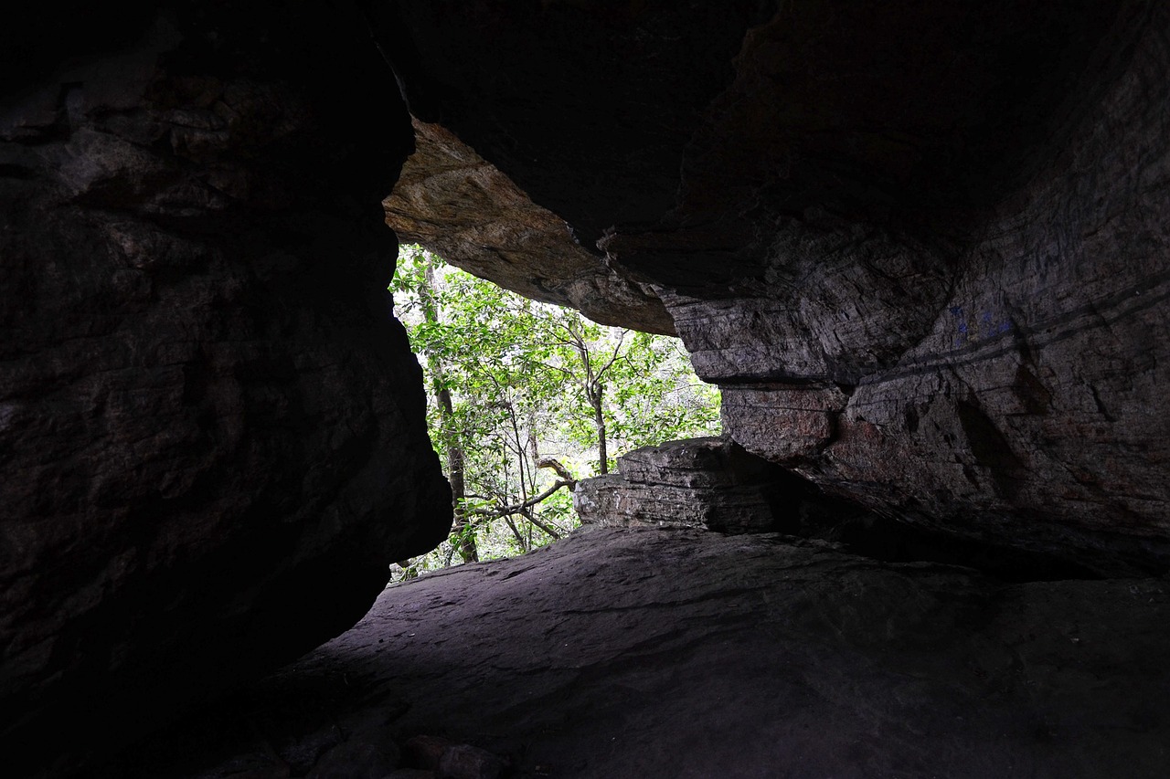
Edakkal Caves are located approximately 40 kilometers from Chembra Peak, accessible via Kalpetta. These ancient rock shelters contain petroglyphic drawings of potential archaeological significance and offer historical and geological interest. The caves are situated in a more accessible location and remain open when Chembra Peak is closed.
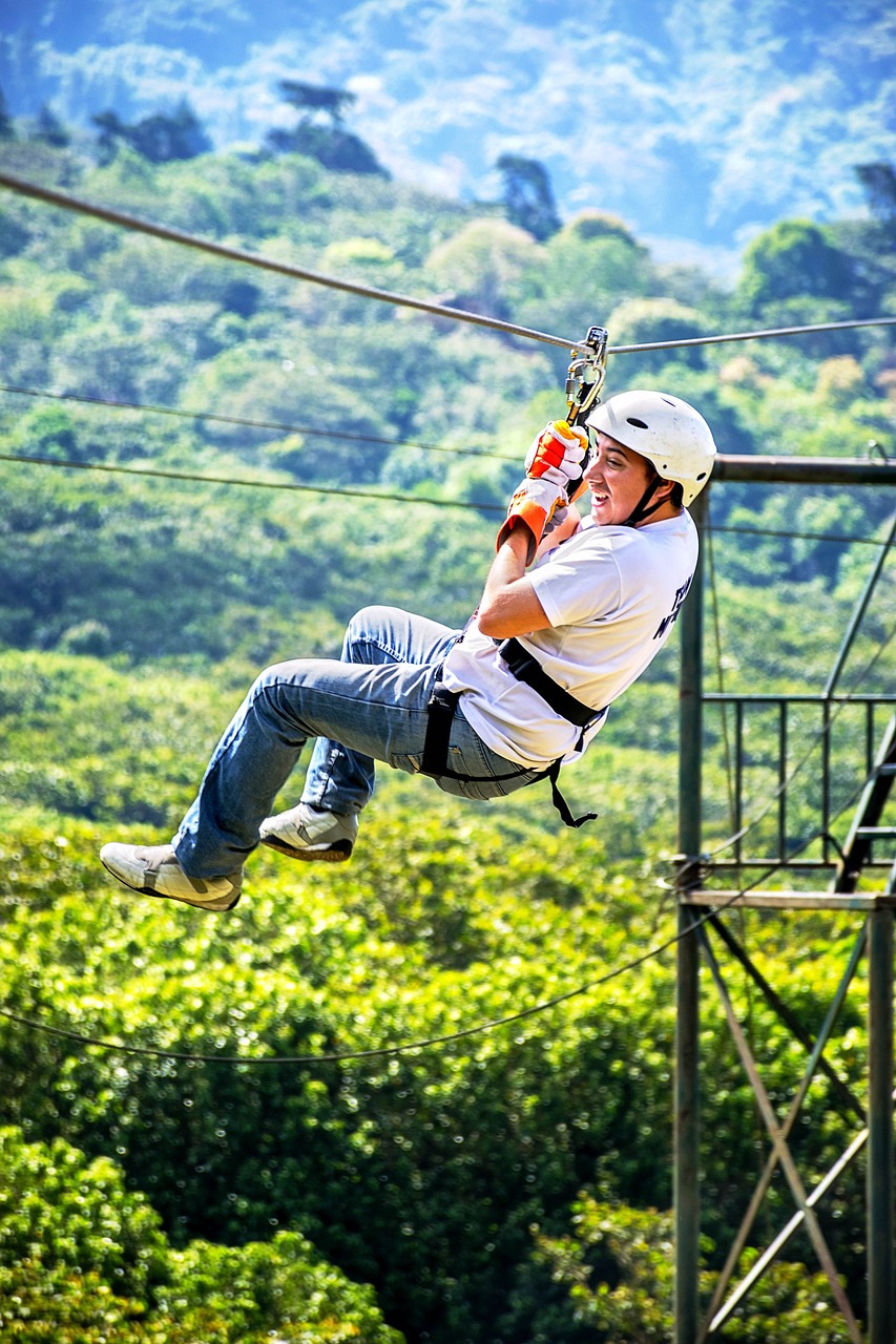
Meppadi Zipline provides adventure activities in the same general region, offering alternative recreational experiences for visitors unable to trek Chembra Peak.
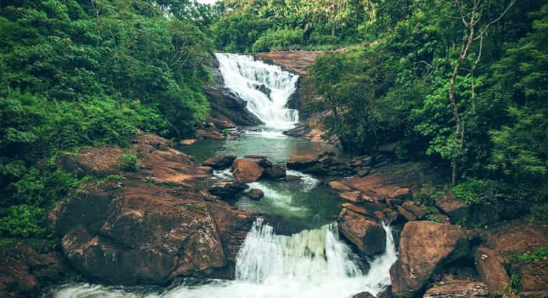
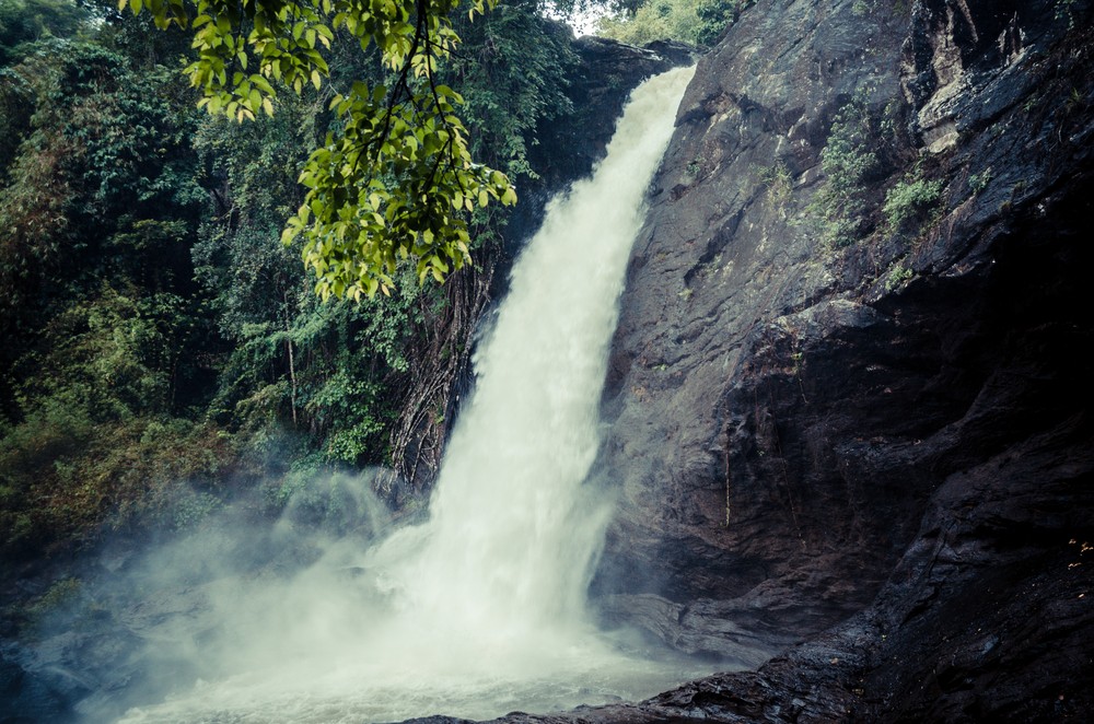
Soochipara Waterfalls (also known as Sentinel Rock Waterfalls) are situated approximately 35 kilometers away, offering scenic waterfall views and picnic facilities.
Kanthanpara Waterfalls provide additional waterfall attractions within Wayanad, featuring cascading water and forest surroundings.
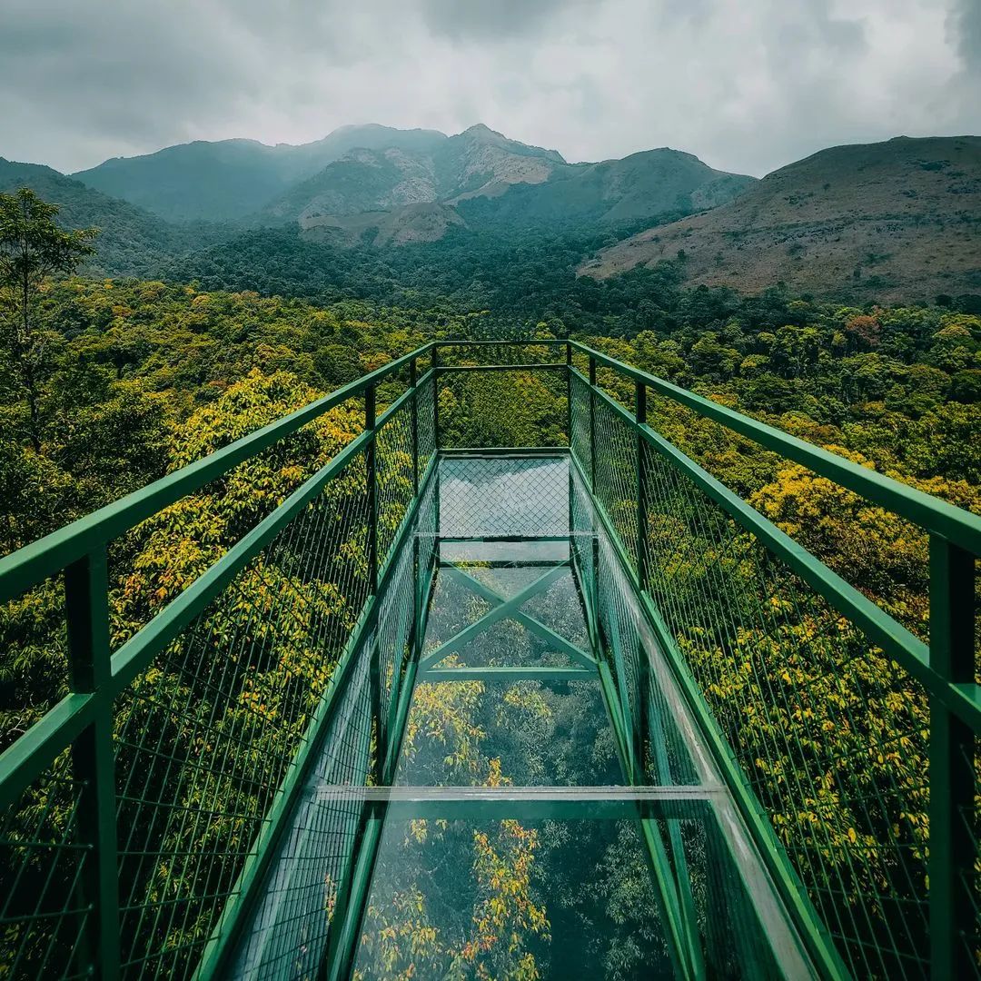
The 900 Kandi Glass Bridge offers a novel attraction providing views of valleys and surrounding landscape, located at approximately 900 meters elevation.
The Lakkidi Viewpoint provides panoramic vistas of Wayanad’s landscape and surrounding areas, accessible by car without requiring trekking.
Entry Fees and Timings
The trekking permit fee is rupees 750 per group (maximum 10 people per group). This fee is collected by the Meppadi Forest Office and supports forest management and conservation initiatives.
The permit office operates from 7:00 AM to 5:00 PM daily, though trekking is permitted only between 9:00 AM and 2:00 PM to ensure adequate daylight for safe descent. Trekking parties should complete their descent before sunset to avoid navigating in darkness.
When the site reopens following landslide recovery, these timings and fees will likely remain in effect, though updates should be confirmed with local authorities.
Local Food and Dining
Meppadi and surrounding areas offer traditional Kerala cuisine through local restaurants and tea stalls. Standard offerings include rice-based meals with vegetable and meat curries, coconut-based preparations, and locally sourced vegetables and spices.
Tea stalls along the roads leading to Meppadi and throughout the region serve hot tea, coffee, and light snacks, providing refreshment for travelers. These establishments are economical and offer authentic local flavors.
Kalpetta, being a larger commercial center, offers a broader range of dining options including restaurants specializing in Kerala cuisine, South Indian cuisine, and some multi-cuisine establishments catering to tourist preferences.
Traditional Kerala items such as appam, puttu, idiyappam, and other regional preparations can be sampled at local restaurants and small eateries. Dishes typically feature coconut, spices, and local vegetables characteristic of Kerala’s culinary tradition.
Accommodation providers, particularly resorts and homestays, typically offer meal packages including breakfast, lunch, and dinner, often featuring Kerala cuisine prepared with local ingredients.
Environmental Responsibility
Conservation of the natural environment is essential given the ecological sensitivity of the Western Ghats and the impact of increased trekking activity.
Littering is strictly prohibited and environmentally damaging. Trekkers must carry all waste materials, including food packaging, plastic bottles, and other debris, back to populated areas for proper disposal. The principle “leave no trace” should guide all activities.
Plastic bags, bottles, and single-use items should be completely avoided. Reusable containers and cloth bags are preferable alternatives for carrying supplies.
Trekkers must remain on established trails to prevent vegetation damage and soil erosion. Off-trail wandering damages delicate alpine vegetation and increases erosion risk.
All Forest Department regulations and instructions from local guides must be strictly followed. These regulations exist to protect both visitors and the environment.
The 2024 landslides have demonstrated the ecological vulnerability of the region. Post-recovery conservation efforts are likely to include restricted access, trail rehabilitation, and revegetation programs. Visitors should respect these conservation measures upon the site’s reopening.
Collecting plants, flowers, or other natural materials is prohibited and can damage fragile ecosystems. Photography is the appropriate way to document natural beauty without environmental harm.
Practical Questions and Tips
How steep is the Chembra Peak trek? The trek involves continuous uphill climbing with varying gradients. The lower sections through tea plantations are moderately sloped, while mid-sections become progressively steeper. The final approach to the heart-shaped lake and beyond involves significant steepness, particularly the final 500 meters to the summit. A reasonable fitness level is necessary, but the trek is not technical rock climbing.
Can children trek to Chembra Peak? Children aged 10 and above with reasonable fitness levels can typically complete the trek with adult supervision and encouragement. Younger children may struggle with the distance and elevation gain. Parents should assess their child’s fitness and hiking experience before undertaking this trek.
What is the permit valid for? Permits are typically valid for a single day and must be used within a specified time window. Permits are non-transferable and valid only for the designated group listed on the permit.
Are guides available? Local guides can be arranged through the Meppadi Forest Office or through accommodation providers. Guides provide navigation assistance, safety management, and local knowledge. Hiring a guide is recommended, particularly for first-time trekkers or those unfamiliar with the terrain.
What is the success rate for summiting? Most trekking parties that depart early and maintain a steady pace successfully reach the peak. A minority turn back due to fatigue, illness, or adverse weather conditions. The key to success is early departure, adequate physical fitness, and appropriate weather selection.
Is there water available during the trek? The heart-shaped lake provides water midway through the trek, though this water should be treated or filtered before consumption. No other reliable water sources exist along the trail, making adequate water carrying essential.
* For exact directions, we recommend contacting our travel desk or using Google Maps navigation.
Explore Trip Plans
Plan Your Visit
Get help with stays, transport & itinerary for Chembra Peak
Chat on WhatsAppFree trip planning assistance
Frequently Asked Questions
how to reach chembra peak?
By Air Fly to Calicut Airport: Nearest Airport: Calicut International Airport, about 85 km from Wayanad. Travel to Kalpetta: Take a taxi or bus to Kalpetta (90 km). By Train Reach Kozhikode Railway Station: Nearest Station: Kozhikode Railway Station, 70 km from Wayanad. Travel to Kalpetta: Take a taxi or bus to Kalpetta. By Road Drive or Bus to Kalpetta: From Cities: Buses or taxis from Bangalore, Mysore, or Kochi. Bus Options: KSRTC buses are available to Kalpetta. From Kalpetta to Chembra Peak Travel to Meppadi: Distance: 12 km from Kalpetta. Options: Take a taxi or local bus. Get Permit at Meppadi: Permit Office: Near Meppadi, required for trekking. Opening Hours: Usually 7:00 AM to 5:00 PM. Drive to Starting Point: Distance: 7 km from Meppadi. Options: Hire a local jeep or drive. Trek to Chembra Peak Start the Trek: Trail: Begins with tea plantations. Distance: 3.5 km one way. Reach Heart-shaped Lake: Midway Landmark: Ideal for rest and photos. Continue to the Summit: Final Climb: Steeper, leading to the peak. Views: Stunning views of Wayanad. Tips Gear: Wear sturdy shoes, carry water and snacks. Guides: Local guides available. Check Weather: Avoid monsoon season. Enjoy your trek to Chembra Peak!
where is chembra peak?
Chembra Peak is located in Wayanad, Kerala, India. Here’s the simple info: Location: Wayanad district, Kerala Nearest Town: Meppadi (about 8 km from Kalpetta) Features: Known for beautiful views and a famous heart-shaped lake To get there, you travel to Meppadi and then trek up to the peak.
how to go to chembra peak?
Fly or Take a Train to Calicut (Kozhikode): Nearest Airport: Calicut (Kozhikode) Airport. Nearest Train Station: Kozhikode Railway Station. Go to Kalpetta: Take a taxi or bus: From Calicut to Kalpetta. Travel to Meppadi: Take a taxi or bus: From Kalpetta to Meppadi. Get Permit: Go to the Meppadi Forest Office: Get a permit for trekking. Reach Trek Start Point: Drive or take a jeep: To the starting point of the trek. Start the Trek: Follow the trail: Trek up to Chembra Peak. That’s it! Enjoy your trek to Chembra Peak!
how long is chembra peak trek?
The trek to Chembra Peak is 7 kilometers round trip: One-way distance: 3.5 kilometers Time to the top: 2-3 hours Total time: 4-5 hours round trip You’ll pass a heart-shaped lake on the way up.
how to reach chembra peak by car?
Drive to Kalpetta: From Calicut (Kozhikode), Bangalore, or Mysore, follow NH766 or NH275 to reach Kalpetta in Wayanad. Proceed to Meppadi: From Kalpetta, drive about 12 kilometers south on the Kalpetta-Meppadi Road. Get Trekking Permit: Stop at the Meppadi Forest Office to obtain a trekking permit for Chembra Peak. Drive to Trek Starting Point: Continue for about 7 kilometers from Meppadi to reach the base of Chembra Peak. Park Your Car: Park your vehicle at the designated parking area near the trek starting point. Start the Trek: Begin the trek from the base to Chembra Peak, which is approximately 3.5 kilometers one way. Summary Distance: Kalpetta to Meppadi (12 km), Meppadi to Chembra Peak base (7 km) Road Condition: The last stretch to the trek start may be rough; consider a vehicle with good clearance. Enjoy your trip to Chembra Peak!
how to reach chembra peak from kalpetta?
Start in Kalpetta: Kalpetta is the main town in Wayanad district, Kerala. Drive to Meppadi: Distance: About 12 kilometers south of Kalpetta. Route: Take the Kalpetta-Meppadi Road. Visit Meppadi: Stop at Meppadi to get a trekking permit from the Forest Department office. Continue to Chembra Peak Base: Drive approximately 7 kilometers further from Meppadi to reach the base of Chembra Peak. Park and Trek: Park your vehicle at the base and start the trek to Chembra Peak, which is about 3.5 kilometers one way. Summary: Kalpetta → Meppadi (12 km) → Get Permit → Meppadi to Chembra Peak Base (7 km) → Trek to Chembra Peak Enjoy your trekking experience to Chembra Peak!
where is chembra peak located?
Chembra Peak is located in the Wayanad district of Kerala, India. It is situated near the town of Meppadi, which is approximately 17 kilometers from Kalpetta, the district headquarters of Wayanad. District: Wayanad State: Kerala, India Nearest Town: Meppadi Distance from Kalpetta: Approximately 17 kilometers
chembra peak which district?
Chembra Peak is located in the Wayanad district of Kerala, India.
chembra peak how to reach?
Start from Kalpetta: Kalpetta is in Wayanad district, Kerala, India. Drive to Meppadi: Distance: About 12 km south of Kalpetta. Route: Follow the Kalpetta-Meppadi Road. Get Trekking Permit: Visit the Forest Department office in Meppadi to get a permit for Chembra Peak trekking. Drive to Chembra Peak Base: Distance: About 7 km from Meppadi. Road: The last stretch can be rough; consider a vehicle with good clearance. Park and Trek: Park your vehicle at the base and start trekking to Chembra Peak, which is about 3.5 km one way. Summary: Kalpetta → Meppadi (12 km) → Get Permit → Meppadi to Chembra Peak Base (7 km) → Trek to Chembra Peak Enjoy your trekking experience to Chembra Peak!
how to book chembra peak trek?
Visit Meppadi Forest Office: Location: Meppadi town, near Chembra Peak in Wayanad, Kerala. Purpose: Go to the Forest Department office to get a trekking permit. Apply for Permit: Details Needed: Provide your name, number of people, and contact information. Fee: Pay the permit fee at the office. Get Your Permit: Once approved, receive your permit which specifies your trekking date and time slot. Consider Hiring a Guide: Guide Option: You can hire a local guide for the trek, arranged through the Forest Department or locally in Meppadi. Start Your Trek: Arrive at the Chembra Peak base as per your permit details and begin your trek. Tips: Plan Ahead: Secure your permit in advance, especially during peak seasons. Local Guidance: A guide can enhance your experience and help navigate the trails safely. Following these steps ensures you can smoothly arrange and enjoy your trek to Chembra Peak in Wayanad.
Is Chembra Peak currently open to visitors?
Chembra Peak is currently closed to visitors due to the landslide issues affecting the Wayanad region. The closure is a precautionary measure to ensure the safety of visitors and address any potential risks resulting from the landslides.
When is Chembra Peak expected to reopen?
The reopening date for Chembra Peak has not yet been determined. The situation is under ongoing assessment, and updates will be provided once it is deemed safe to reopen. For the latest information, please check local news sources or contact local authorities.
What caused the closure of Chembra Peak?
The closure of Chembra Peak is due to recent landslides in Wayanad, which have impacted the accessibility and safety of the trekking routes and surrounding areas. The decision to close the site is to prevent accidents and manage the impact of these natural events.
Are there other attractions or activities to enjoy in Wayanad while Chembra Peak is closed?
Yes, there are several other attractions and activities in Wayanad that you can explore. Consider visiting places like Edakkal Caves, Pookode Lake, or the scenic viewpoints in the Wayanad Wildlife Sanctuary. Be sure to check the current status of these sites and local travel advisories before planning your visit.
Can I get a refund for any bookings or fees related to Chembra Peak?
For information on refunds or rescheduling related to Chembra Peak, please contact the relevant service providers or tour operators. They will assist you with refund requests or provide alternative arrangements if needed.
How can I stay updated on the status of Chembra Peak?
To stay informed about Chembra Peak, monitor local news, visit official websites, or follow social media channels for updates. Signing up for notifications or alerts, if available, can also help you receive the latest information about the peak and its accessibility.
Nearby Places to Explore
 attraction
 900 Kandi Glass Bridge
Experience the thrill of South India's first glass bridge at 900 Kandi, Wayanad. Walk 100 meters above the forest canopy, enjoy offroad jeep safari adventure through pristine wilderness, and discover one of Kerala's most unique attractions.
 attraction
 Kanthanpara Waterfalls
Kanthanpara Waterfalls is a breathtaking natural wonder located in the heart of Wayanad.
 attraction
 Meppadi Zipline
Meppadi Zipline offers an exhilarating experience for adventure enthusiasts. Currently temporarily closed pending reopening assessment following 2024 landslides.
 attraction
 Soochipara Waterfalls
Soochipara Waterfalls in Wayanad — a three-tiered waterfall with natural swimming pool, rock sliding, and 1.5 km forest trek. Entry ₹80–150. Open now.
 attraction
 Edakkal Caves
Ancient caves with prehistoric petroglyphs, offering a glimpse into human civilization from the Neolithic age.