
Neelimala Viewpoint
Neelimala Viewpoint offers a breathtaking panorama of nature’s beauty.
Neelimala Viewpoint is a panoramic observation point located between Kalpetta and Meppadi in Wayanad’s Western Ghats, offering sweeping 360-degree vistas of verdant valleys, the distant Meenmutty Falls, sprawling tea plantations, and the dramatic mountain ranges that define Kerala’s high country.
Current Status
Neelimala Viewpoint is currently closed to visitors as a precautionary measure following landslide events in the Wayanad region. Safety assessments and infrastructure stabilization work are ongoing. The situation remains under active evaluation, and reopening timelines have not yet been confirmed. Visitors are advised to check local travel advisories and contact Wayanad district authorities for the latest status updates before planning visits to this location or nearby alternatives.
Location and Geography
Neelimala Viewpoint is situated in the Wayanad district of Kerala’s high-altitude plateau, positioned strategically between the towns of Kalpetta (approximately 16 kilometers away) and Meppadi (approximately 12 kilometers away) along the scenic Ooty-Kalpetta Road corridor. The viewpoint occupies an elevation of roughly 1,600 meters above sea level, making it one of the region’s most prominent observation points.
The geographical position of Neelimala places it within the transition zone between the tropical moist deciduous forests of lower elevations and the montane shola forest ecosystem of higher altitudes. This positioning provides visitors with an unobstructed panoramic view that encompasses the entire Wayanad plateau’s dramatic topography. The viewpoint overlooks the deep ravines and gorges that have been carved by ancient water courses, including the path that feeds the spectacular Meenmutty Falls visible from this vantage point.
The area forms part of the larger Western Ghats mountain range, a UNESCO World Heritage site recognized for its exceptional biodiversity and geological significance. The Neelimala region specifically showcases the characteristic features of the Wayanad plateau’s landscape: rolling grasslands interspersed with patches of evergreen forest, tea-covered slopes visible across the valley, and the dramatic cliff faces that are evidence of the region’s ancient geological formations.
How to Reach
By Road from Kalpetta
From Kalpetta, the district headquarters, Neelimala Viewpoint is approximately 16 kilometers away. The route follows the scenic Ooty-Kalpetta Road (National Highway 766), which winds through tea estates and forest patches. From Kalpetta town center, travelers should head towards the NH766 northeast bypass. The journey typically takes 30-45 minutes by private vehicle, depending on traffic conditions and weather.
By Road from Meppadi
Meppadi, a smaller hill station closer to Neelimala, offers a shorter approach route of approximately 12 kilometers. From Meppadi town, the road ascends gradually through agricultural areas and forest patches before reaching the viewpoint base. This route takes approximately 25-35 minutes by vehicle and is often preferred by those staying in the Meppadi area or approaching from the Ooty side.
Trekking Access
The most authentic way to experience Neelimala is through the trekking route that begins from the nearby village of Vaduvanchal. Local guides, typically available through homestays and small tourism operations in the area, facilitate this trek. The trek itself is moderate in difficulty, suitable for visitors with basic fitness levels. Guides are strongly recommended, both for safety and to gain insights into the local flora, fauna, and cultural history of the area.
Transportation Options
- Private Vehicle or Taxi: Recommended option offering flexibility and comfort
- Rental Jeeps: Available in Kalpetta and Meppadi, suitable for rough terrain near the viewpoint base
- Local Buses: Connect Kalpetta and Meppadi, with possible connections through Vaduvanchal, though schedules are limited
The Viewpoint Experience
Standing at Neelimala, visitors are rewarded with one of Wayanad’s most comprehensive panoramic vistas. The viewpoint experience is transformative, particularly during clear weather conditions when visibility extends for tens of kilometers across the landscape.
Primary Views and Landmarks
The most prominent feature visible from Neelimala is the Meenmutty Falls, appearing as a silvery thread cascading down the distant cliff face. Though the falls are typically 8-10 kilometers away, the elevation and clear air make them a striking visual focal point, especially when water flow is substantial during or after monsoon months.
The surrounding valleys create a sea of undulating green, particularly striking from October through May when mist layers settle in the valley bottoms during early mornings and late afternoons. These natural mists create ethereal landscapes, with distant hills fading into white haze—a photographer’s dream scenario.
The tea plantations that blanket many of the surrounding slopes display geometric patterns of cultivation, creating a striking contrast to the wild forest areas. During the flush season (spring), the bright green of new leaf growth makes these plantations particularly vivid.
The Western Ghats Panorama
The broader Western Ghats mountain range forms the dramatic backdrop of the Neelimala vista. Multiple ridgelines stack into the distance, each progressively fainter, creating a sense of profound depth and scale. On exceptionally clear days, particularly after the monsoon rains have washed the atmosphere clean, visibility can extend to mountains more than 30 kilometers away.
Valley and Ravine Systems
The complex system of valleys and ravines visible from Neelimala tells the geological story of the Western Ghats. Deep gorges carved by ancient water erosion demonstrate the region’s dramatic terrain. These ravines are often lined with lush vegetation, forming dark green corridors that contrast with the lighter cultivated areas.
Trek Route to Meenmutty Falls
While Neelimala itself is a primary destination, many visitors undertake a more extended trek from the viewpoint area down towards Meenmutty Falls for an immersive forest and waterfall experience.
Trek Details
Total Distance: Approximately 8-10 kilometers round trip from Neelimala viewpoint area to Meenmutty Falls base
Duration: 5-6 hours for the complete round-trip trek, accounting for exploration time at the falls
Difficulty Level: Moderate to moderately challenging, requiring reasonable fitness and surefootedness
Trail Characteristics: The trek descends through mixed forest types, featuring both well-defined paths and sections requiring careful navigation over rocky terrain and tree roots. Multiple stream crossings occur, particularly during monsoon and post-monsoon seasons.
Trail Conditions
During the dry season (October-May), the trail is generally well-maintained and manageable for experienced trekkers. Stream volumes are minimal, making crossings straightforward. During monsoon and immediate post-monsoon months (June-September), the trail becomes significantly more challenging, with slippery surfaces, swollen streams, and reduced visibility from mist and vegetation overgrowth.
Flora Along the Trek Route
The trek passes through several distinct ecological zones. Upper elevations feature montane evergreen forests with towering shade trees, followed by descents through mixed shola forest patches interspersed with grassland clearings. Near the falls, the vegetation becomes increasingly humid and lush, with ferns, mosses, and orchids thriving in the spray zone.
Sunrise and Sunset Experiences
Sunrise Viewing
Arriving at Neelimala before dawn offers one of Wayanad’s most spectacular natural light shows. As the sun rises over the distant eastern hills, the landscape transforms through a sequence of color palettes: deep purples and indigos give way to oranges and reds, followed by golden yellows as the sun clears the horizon. The sun’s rays often penetrate the valley mist layers, creating dramatic crepuscular rays that stream through the haze—an intensely photogenic phenomenon.
Sunrise timing varies seasonally: October through November, sunrise occurs around 6:15-6:45 AM; December through January, around 6:45-7:15 AM; February through April, around 6:00-6:30 AM. Arriving 45 minutes before sunrise ensures adequate positioning and light adjustment time.
Sunset Viewing
The setting sun bathes the landscape in warm golden and amber tones, backlighting the distant hills and creating silhouettes of ridgelines. Sunset occurs progressively earlier from October (around 5:45-6:15 PM) through December (around 5:00-5:30 PM) and extends to later times from January (around 5:30-6:00 PM) through May (around 6:15-6:45 PM). The atmosphere often becomes clearer toward sunset as wind patterns disperse morning mists, potentially offering better clarity than sunrise.
Golden Hour Photography
The two-hour period straddling sunrise (one hour before through one hour after) and sunset offer ideal lighting conditions. Colors are warm, contrast is reduced, and the low angle of light emphasizes terrain features and landscape depth.
Flora and Fauna
Vegetation Zones
Neelimala’s elevation supports distinct vegetation communities characteristic of the Western Ghats’ montane environment.
Montane Evergreen Forest: The primary forest type surrounding the viewpoint features dense canopy coverage with towering shade trees reaching 20-30 meters in height. These forests remain green year-round, relying on moisture from fog and mist rather than seasonal rainfall. Dominant tree species include members of the laurel and myrtaceae families, along with various endemics found nowhere else on earth.
Shola Forest Patches: These unique grassland-and-forest mosaic ecosystems occur in sheltered valleys and depressions. Characteristic montane grasslands dominate exposed areas, while dense shola forest occupies protected ravines and gullies. This distinctive ecosystem is particularly rich in endemic species found only in the Western Ghats.
Tea Plantations: The extensive tea plantations visible across the landscape represent both economic activity and habitat modification. While not natural ecosystems, these areas do support bird populations and some ground-dwelling wildlife.
Wildlife
The area around Neelimala supports a diverse array of fauna, though large animals are rarely encountered by day visitors.
Mammals: Populations include spotted deer, sambar, wild boar, and occasionally leopards in remote areas. Small mammals like civets, shrews, and various rodent species are common.
Birds: The region is notable for bird diversity, particularly among endemic species. Mountain hawk-eagles, steppe eagles, nilgiri woodpigeons, and Nilgiri flycatchers are among the specialties. The area also attracts migratory birds during winter months.
Reptiles and Amphibians: The moist forest environment supports numerous reptile species, including endemic snakes, lizards, and gekkonids. During monsoon, frogs and toads are particularly vocal and visible.
Best Time to Visit
October to May: Optimal Visiting Season
October to November: Post-monsoon season with clearing skies, excellent visibility, and moderately cool temperatures (18-24°C). Morning mists create dramatic lighting conditions. Vegetation remains lush from monsoon rains. This is considered the prime visiting season.
December to January: Coolest months (12-18°C) with typically clear skies and excellent visibility across the landscape. These months attract significant visitor numbers. However, early morning temperatures can approach near-freezing at the viewpoint’s elevation.
February to April: Dry season with warm temperatures (20-26°C) and generally clear visibility. March and early April can see some haze from agricultural burning in lower elevations, potentially reducing visibility. Late April heat becomes more pronounced, though mornings remain pleasant.
June to September: Monsoon Season
While the viewpoint is typically closed or difficult to access during peak monsoon (July-August), the post-monsoon transition period (September) can offer opportunities for experienced trekkers. The landscape is at its greenest, and afternoon clearing sometimes provides dramatic lighting. However, trails are slippery, visibility is limited by mist and clouds, and sudden weather changes can create safety hazards.
Entry Fees and Timings
Current Status
As of the current closure following landslide safety concerns, formal visiting hours and fee structures are not applicable. However, historical information provides context for when operations resume:
Standard Operating Hours (Historical)
- Opening Time: 6:00 AM
- Closing Time: 6:00 PM
- Best Time to Arrive: 1-2 hours before sunrise for sunrise viewing; 2-3 hours before sunset for sunset viewing
Entry Fees
Historically, no formal entrance fee has been charged at Neelimala Viewpoint itself. However, visitors typically incur costs for:
- Local Guide Services: 500-800 Indian Rupees for half-day guidance
- Vehicle Parking: Minimal fees where available (100-200 Indian Rupees)
- Jeep Transportation: If using rental jeeps from base points (500-1,500 Indian Rupees depending on distance and duration)
Photography Tips
Equipment Recommendations
Wide-Angle Lenses: Essential for capturing the expansive panoramic vistas. Lenses in the 16-35mm range (full-frame equivalent) or similar are ideal for landscape photography.
Telephoto Lenses: Useful for isolating distant features, particularly for capturing Meenmutty Falls or compressing landscape layers. 70-200mm range lenses excel at this purpose.
Polarizing Filters: Particularly effective for reducing haze and enhancing sky color and saturation, especially during clear-day conditions.
Neutral Density Filters: For sunrise and sunset work, graduated ND filters can help balance exposure between sky and landscape.
Tripods: Essential for sunrise and sunset work when light levels are lower and shutter speeds require stability.
Composition Strategies
Foreground Interest: Include prominent rocks, vegetation, or terrain features in the immediate foreground to create depth and lead viewers’ eyes into the composition.
Leading Lines: Use valleys, ridgelines, and mist layers to create compositional lines that draw attention through the image.
Layering: Leverage the multiple ridgelines receding into the distance to create a sense of profound depth and scale.
Mist and Mood: Morning and evening mist layers create atmospheric, moody compositions. These conditions are often more interesting photographically than clear, flat light.
Best Photography Times
- Sunrise: 30-90 minutes after sunrise for warm light and atmospheric conditions
- Golden Hour: First and last two hours of daylight
- Blue Hour: 20-40 minutes before sunrise and after sunset for cool-toned, twilight compositions
- Mist Photography: Early mornings, particularly September through March
Safety Guidelines
General Safety Considerations
Altitude and Physical Exertion: While Neelimala’s elevation (approximately 1,600 meters) is moderate, visitors unaccustomed to high elevations may experience mild breathlessness or headache. Ascending gradually and staying well-hydrated help mitigate altitude effects.
Weather Changes: Mountain weather can change rapidly. Morning clarity can give way to afternoon mist and cloud cover. Afternoon electrical storms occur frequently during monsoon transition periods. Check weather forecasts and be prepared to descend if conditions deteriorate.
Trail Hazards: Rocky, uneven ground and tree roots present tripping hazards. Proper footwear with good grip is essential. During wet conditions, slipping risks increase significantly.
Stream Crossings: During and after monsoon, streams can swell rapidly from upstream rainfall. Never attempt to cross swollen streams; wait for water levels to subside or return on another day.
Night Safety
The viewpoint should only be visited during daylight hours. Attempting to reach the viewpoint in darkness or descending after dark creates serious safety risks on unlit, uneven trails. Arrange timing to depart before sunset.
Solo Travel Considerations
While Neelimala can be visited solo, hiring a local guide is recommended, particularly for first-time visitors or those unfamiliar with the trails. Guides provide not only directional assistance but also safety management in remote areas.
What to Pack
Essential Items
- Water: Minimum 2 liters per person; 3-4 liters if trekking to Meenmutty Falls
- Sunscreen: High-SPF protection (30+); reapply every 2 hours and after sweating
- Hat or Cap: Essential sun protection, particularly at altitude
- Footwear: Sturdy hiking boots or trekking shoes with good grip and ankle support
- Light Layers: Early morning and evening temperatures are cool; bring a lightweight fleece or windproof jacket
- Snacks: High-energy options including nuts, energy bars, and fruit
- First Aid Kit: Basic supplies including adhesive bandages, pain relievers, and blister treatment
- Headlamp or Flashlight: Essential if visiting for sunrise and arriving before dawn
Optional but Recommended
- Camera and Lenses: For photography enthusiasts
- Binoculars: For bird watching and wildlife spotting
- Insect Repellent: Particularly important during monsoon months
- Lighter Rain Jacket: Even during dry season, weather can change
- Portable Phone Charger: Useful for emergencies and documentation
- Trekking Poles: Helpful for descent stability and reducing joint stress
Accommodation Nearby
Kalpetta (16 km away)
As Wayanad’s primary town, Kalpetta offers the widest accommodation range, from budget guesthouses to mid-range hotels:
- Christy’s Palace Resort: Mid-range resort with comfortable amenities
- The Wayanad Gate: Contemporary hotel with modern facilities
- Budget Options: Several homestays and small guesthouses offering basic facilities
Meppadi (12 km away)
Meppadi, the closest larger settlement, provides excellent accommodation options:
- Misty Mountain Resort: Popular mid-range property with hill station ambiance
- Homestays and Guesthouses: Numerous family-run options offering authentic local experiences
Vaduvanchal Area (Base village for Neelimala Trek)
- Local Homestays: Several families operate homestays offering authentic hill village experiences
- Very basic facilities: Expect minimal luxury, local food, and intimate connection with local communities
Vythiri (Alternative, 20 km away)
- Vythiri Resort: Premium property with extensive amenities
- Pepper Trail: Boutique heritage resort
- Mid-range options: Several good quality hotels
Nearby Attractions
The area surrounding Neelimala contains several complementary attractions that can be incorporated into extended visits:
Meenmutty Waterfalls
Located approximately 8-10 kilometers from Neelimala Viewpoint, Meenmutty Waterfalls represent a magnificent three-tiered cascade that plunges over 1,500 meters in total vertical drop. The falls are often visible from Neelimala itself, appearing as a silvery thread in the distance. A trek from the viewpoint area down to the base of the falls creates an extended 8-10 kilometer round-trip adventure through diverse forest ecosystems. The falls are most spectacular during and immediately after monsoon when water volume is maximum.
Soochipara Waterfalls
Soochipara Waterfalls, also known as Sentinel Rock Waterfalls, is located approximately 15-20 kilometers from Neelimala. Like Meenmutty, Soochipara features impressive cascades in a dramatic gorge setting. The trek to Soochipara involves descent and moderate climbing, making it more challenging than some other Wayanad waterfalls. Swimming pools beneath the falls offer refreshing water immersion opportunities.
Chembra Peak
Situated approximately 12-18 kilometers from Neelimala, Chembra Peak stands at 2,100 meters, making it the highest point in Wayanad. The distinctive heart-shaped lake at the summit is a unique geographical feature. Chembra offers vistas comparable to Neelimala but from a different orientation, providing complementary perspectives of the Wayanad landscape.
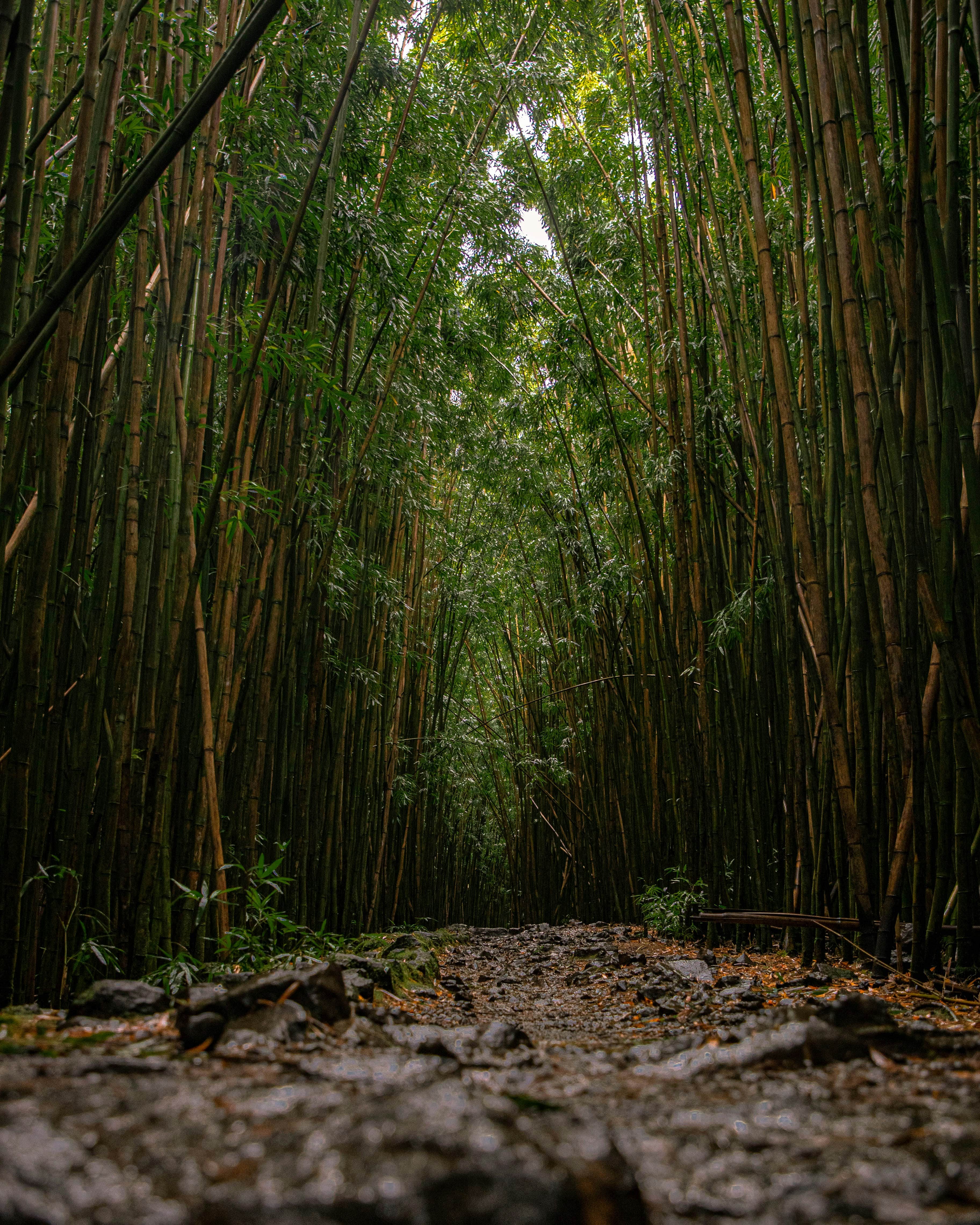
Bamboo Forest
The scenic Bamboo Forest, approximately 8-12 kilometers from Neelimala, offers a distinctly different ecosystem experience. The towering bamboo groves create an ethereal, quiet atmosphere. Visitors can trek through the dense forest, experiencing the unique ecology and understory landscape. The forest is particularly photogenic in morning light filtering through the bamboo stalks.
Experiencing Neelimala Responsibly
As a fragile high-altitude ecosystem within the Western Ghats, Neelimala requires thoughtful visitor management:
- Stay on Established Trails: Reduce erosion and vegetation damage by adhering to marked paths
- Leave No Trace: Carry out all refuse, including organic items that take time to decompose at altitude
- Minimize Noise: Respect the peaceful environment and avoid startling wildlife
- Respect Closure Periods: Until the current safety closure is lifted and the viewpoint officially reopens, respect the closure to allow for necessary restoration work
- Support Local Communities: Engage local guides and homestay providers to ensure economic benefits reach local populations
* For exact directions, we recommend contacting our travel desk or using Google Maps navigation.
Explore Trip Plans
Plan Your Visit
Get help with stays, transport & itinerary for Neelimala Viewpoint
Chat on WhatsAppFree trip planning assistance
Frequently Asked Questions
Is Neelimala Viewpoint currently open to visitors?
Neelimala Viewpoint is currently closed to visitors due to the landslide issues affecting the Wayanad region. The closure is a precautionary measure to ensure the safety of visitors and to address any potential risks resulting from the landslides.
When is Neelimala Viewpoint expected to reopen?
The reopening date for Neelimala Viewpoint has not yet been confirmed. The situation is under ongoing assessment, and updates will be provided once it is deemed safe to reopen the area. For the latest information, please check local news sources or contact local authorities.
What caused the closure of Neelimala Viewpoint?
The closure of Neelimala Viewpoint is due to recent landslides in Wayanad, which have impacted the accessibility and safety of the area. The decision to close the viewpoint is to prevent accidents and manage the impact of these natural events.
Are there other attractions or viewpoints to visit in Wayanad while Neelimala Viewpoint is closed?
Yes, there are several other attractions and viewpoints in Wayanad that you can explore. Consider visiting places like Chembra Peak, Pookode Lake, or Edakkal Caves. Always verify the status of these sites and check local travel advisories before planning your visit.
Can I get a refund for any bookings or fees related to Neelimala Viewpoint?
For information on refunds or rescheduling related to Neelimala Viewpoint, please contact the relevant service providers or tour operators. They will assist you with refund requests or provide alternatives if necessary.
How can I stay updated on the status of Neelimala Viewpoint?
To stay informed about Neelimala Viewpoint, monitor local news, visit official websites, or follow social media channels for updates. You may also sign up for notifications or alerts, if available, to receive the latest information about the viewpoint and its accessibility.
What is Neelimala Viewpoint?
Neelimala Viewpoint is a scenic vantage point in Wayanad, Kerala, known for its breathtaking views of the surrounding hills, valleys, and the cascading Meenmutty Falls. It is a popular destination for nature lovers and photographers.
Where is Neelimala Viewpoint located?
Neelimala Viewpoint is located in the Wayanad district of Kerala, near the town of Vaduvanchal. It is approximately 27 kilometers from Kalpetta, the district headquarters of Wayanad.
How can I reach Neelimala Viewpoint?
The viewpoint is accessible by a short trek from the nearest road accessible by jeeps or other vehicles. The base point for the trek is usually from Vaduvanchal, and local guides are available to help navigate the path.
What can I see from Neelimala Viewpoint?
From Neelimala Viewpoint, you can see panoramic views of lush green landscapes, the Western Ghats, and the stunning Meenmutty Falls. The area is also rich in biodiversity, offering sights of various plant and animal species.
Is Neelimala Viewpoint suitable for photography?
Yes, Neelimala Viewpoint is an excellent spot for photography, especially for capturing the scenic beauty of Wayanad, the waterfalls, and the surrounding mountains. Sunrise and sunset are particularly good times for photos.
What other attractions are near Neelimala Viewpoint?
Other nearby attractions include Meenmutty Falls, Edakkal Caves, and Chembra Peak. These sites offer additional opportunities for trekking, exploring, and enjoying the natural beauty of Wayanad.
What are the opening hours for Neelimala Viewpoint?
Neelimala Viewpoint is typically open to visitors from early morning until sunset. It is recommended to visit during daylight hours for safety and to make the most of the views.
What is the distance from Neelimala Viewpoint to Meenmutty Falls?
The distance from Neelimala Viewpoint to Meenmutty Falls is about 3 kilometers, making it a short trek for visitors who wish to explore both sites in one visit.
What is the best time to visit Neelimala Viewpoint?
The best time to visit is from October to May when the weather is clear, and the views are unobstructed. The monsoon season can make the trails slippery and challenging, so it's best to avoid visiting during heavy rains.
Is there any entry fee for Neelimala Viewpoint?
There is usually no formal entry fee for the viewpoint itself, but you may need to pay for the services of a local guide or for transportation to the starting point of the trek.
Can I visit Neelimala Viewpoint with children?
Yes, the viewpoint is suitable for families with children who are capable of handling a short trek. Parents should ensure that children are supervised, especially near steep edges and rough paths.
Are there any facilities available at Neelimala Viewpoint?
Facilities at the viewpoint are limited. It’s a good idea to prepare for a basic outdoor experience without amenities like restrooms or food stalls. Bring any necessary supplies with you.
What is the nearest town to Neelimala Viewpoint?
The nearest town to Neelimala Viewpoint is Vaduvanchal. It is a small town where you can find basic services and transport options to the base of the trek.
Nearby Places to Explore
 attraction
 Bamboo Forest
Visit the Bamboo Forest in Wayanad — a natural bamboo grove near Muthanga with towering 30-metre culms, free entry, wildlife sightings, and easy forest walks. 20 km from Kalpetta.
 attraction
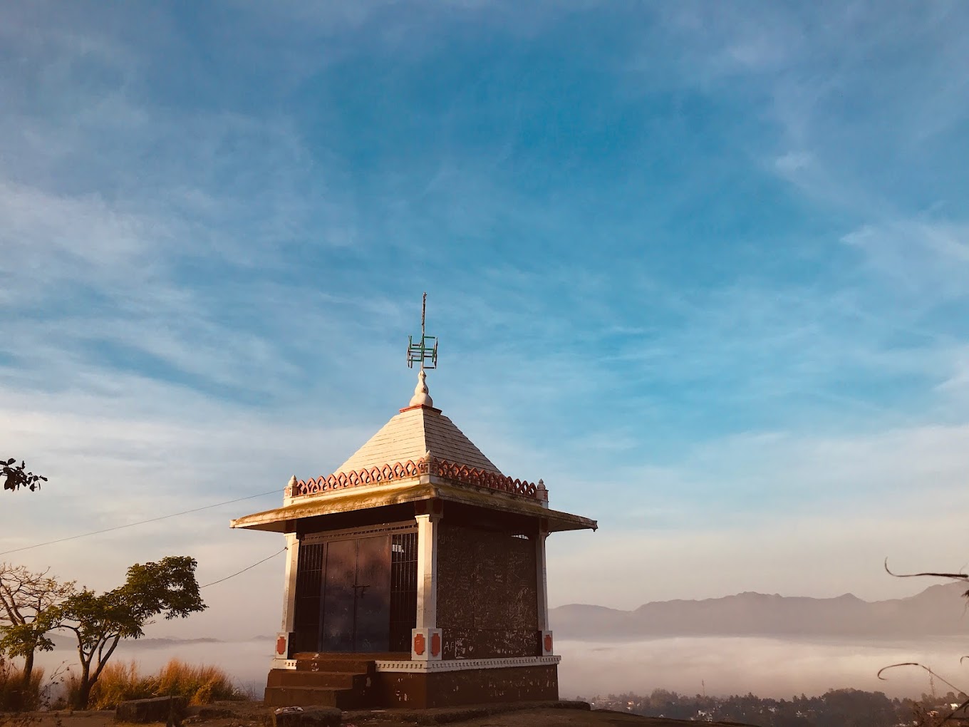
 Myladippara
Myladippara is a picturesque viewpoint in Wayanad.
 attraction
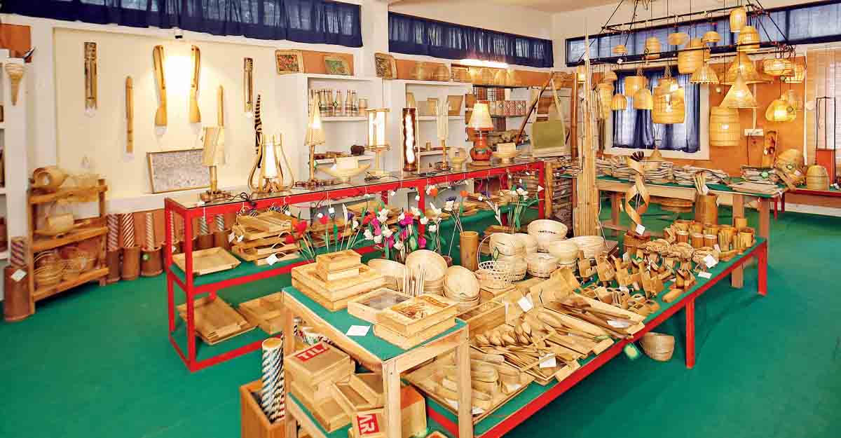
 The Bamboo Factory
The Bamboo Factory stands as a beacon of traditional craftsmanship and cultural heritage.